KALAMINA & WEANO GORGES

This is Wickham’s Grevillea

We were up and about early today. Last night was freezing (must have been zero or less) and this morning, slightly warmer (two degrees). It is so cold at night that, as soon as the sun drops, it seems everyone in camp is in bed by 7pm. It is better to get an early start, get out walking, then come home for a late lunch and rest. This afternoon, we have to pack up, and make our way to Cape Range.

By 10:00am, we were ready to make the descent into Kalamina Gorge, 40kms from camp.

More steps, but then a wonderful walk to the waterfalls, and then a stroll through the lower level of the gorge, with the river cascading over rocks all the way, crossing the shallow river in a few of places.

Stopped at the last river crossing, about 3/4rds of the way to the end and decided to amble back and make the ascent. This bit makes my huff and puff, but Russ bounds up as if he’s a mountain goat (oops).

In the car again and on to Weano Gorge. A long way to drive, over a corrugated and rocky road, but arrived at Oxers Lookout – a short walk took us to a man-made structure overlooking the gorge, at least 100 metres up. We both found it difficult to get to the edge. Russ only took one photo here.

A walk along a narrow track took us to another lookout, where we could see the narrowness of the gorge. Russ thought that in places it might only be one metre wide. The MM were pleased we had left them in the car, as they are ‘gorged’ out, but we think that they are a little bit scared of heights! Yellow MM would be highly insulted and get quite agro if we even hinted anything along those lines.

This is a photo of our camp site at Karijini.

Posted in 2008 | Leave a comment

Karijini

We might have had a bad day on our way here, but all I can say is it was worth the worry, cost of repairs and three days in Tom Price.

After getting my hair cut at 9:30am, (Tom Price time 9:45, plus an hour for the cut), we set off for our most looked forward to destination – Karijini.

The banded iron formations exposed in many of the rocks around the gorges are more than 2,500 million years old, as iron and silica-rich sediment deposits accumulated on an ancient sea floor. Over millions of years these deposits were transformed by the pressure of further sediments laid down over them, forcing trapped water to be driven out and gradually turning the sediments into tough, well-bedded rock.

Horizontal compression later caused the rocks to buckle, developing numerous vertical cracks, before lifting to the surface to form dry land. A sharp drop in sea-level caused the rivers to cut down rapidly through the land, creating sheer-sided gorges. This, combined with millions of years of erosion, has sculptured the rocks into the present landscape.

There are many dingoes here, heard howling at approx. 4:00am, and there is a little mouse, named the pebble mound mouse, which piles mounds of rocks up beside its home.

We have a site on the Euro Loop Road, one of seven loops, carefully planned and each loop well situated throughout the park. Every site has some bush between the next site and people with generators are in an area on their own.

The views from the sites aren’t as scenic as other parks, but the walks are unbelievable.

Today we walked to Circular Pool, where I declined to take a Class 4 track – walking down rocks, down the side of a cliff. Walked along the top of the gorge until we came to the Class 3 walk to Fortesque Falls, which then continues to Fern Pool. It was the best thing I have ever done, even though we had to walk down 150 steep steps (with hand rail for 1/8 of the way, then some light fencing and sturdy posts, the rest of the way and the odd tree).

Fortesque Falls was magnificent, and the gorge was one of the deepest ones we’ve been in so far. Many young European tourists swimming in the 8 degree temperature pool, having a wonderful time.

Walked on to Fern Pool, my favourite place of all time, so far. We had the area to ourselves for 15 minutes or so, then more tourists madly changing into their bathers, and diving in. The atmosphere changed, but nothing could change the stunning beauty of the place and the walk back meant we could enjoy it all over again.

MM had a wonderful swim with the tourists and when we got back, were pegged up on the line, with their towels, to dry, while we had our showers.

Feeling frisky after their swim, they talked us into a bit of line-dancing! They never stop these guys. They were quite upset about the dirt here – it is attracted to them, it has magnetic properties. The static here is amazing here and I am constantly being ‘zapped’, as are other females, but not the guys.

Posted in 2008 | Leave a comment

TOM PRICE AND HAMERSLEY GORGE

I’m writing this on our third day here. We are feeling more settled and have recovered from our ordeal. Russ has organised all the repairs, bought a new tyre and has replaced the faulty spare.

Tom Price is an Iron Ore mining town, with a post office, supermarket, hairdresser, hardware etc. Just the bare necessities, except a bakery and a hospital. I’ve tried to book in to have my hair cut, but she hasn’t opened for the last two days! (She’s just rung and I have an appointment at 9:30am tomorrow). I’ll get a bit of a serve from her, because I’ve had a go at cutting it myself.

We have been able to link up to mains water and have a powered site, which is a must, as the nights and mornings are freezing – four degrees – with a very cold wind; the locals tell us that Karijini National Park is even colder – our next destination.

The birds here are lovely; tame galahs and crested pigeons, what haven’t made a nuisance of themselves, but seem to like the company. MM not too happy when they flew up and sat on Parps, though Parps thought it was great fun.

Today, we drove into Hamersley Gorge – Part of Karajini National Park. Spectacular gorge, with permanent pools and waterfalls, requiring a steep walk down steps (and back again, of course)! Large termite mounds dotted the beautiful countryside, amongst stunning white-trunked eucalypts, with the massive Hamersley Range in the background.

The MM had a great time on the termite mounds, until the ants thought enough was enough! One last fling, with the range in the background. Little devils.

On the way home, we took Railway Road. A road that is owned and controlled by the mine, and requires a permit and viewing of a ten-minute video, showing road safety and dangers that may be encountered. I was a little apprehensive, (thinking of our repaired tyres), but the road was better than the Nat Park road that we took to enter the range! We saw a train, and we lost count of its carriages, at what we think was nearly 200!

Two-thirds of the way back, a car came towards us, on our side of the road, rather daunting, until we realised that he was asking us to pull off the road completely, to make way for two wide-loads following. We did so, waited a fair while, then saw these massive trucks, carrying mine vehicles. They took up the entire road width and the wheels must have been four metres high! The MM hid under my seat, they felt so little! They also blocked their ears, because of the noise of the engines of the trucks.

We’ll probably be at Karijini for 5-7 days, depending on the weather and the place itself. There won’t be any mobile coverage, but messages can be left on our Satt phone.

Posted in 2008 | 2 Comments

MOUNT AUGUSTUS TO TOM PRICE – A DAY THAT WILL NEVER BE FORGOTTEN!


I realized in my last blog that I didn’t include many photos of Mt Augustus. Here are a few, but they don’t show the enormity of it. There is also the view from our camp site.

Easy pack up today, with the roof taken down yesterday and set off at 8:30am, looking forward to what sounds like a difficult, but picturesque road.

Saw a very healthy dingo a few kms into the trip. Gibber plains most of the way, glistening in the sun, as if covered by a heavy frost!

The road has surprised us, to say the least, traveling only 40-60kph on the easier bits, and 10-20kph through the riverbeds. Very slow going, through high crests, deep dips, long (dry) riverbeds, twisting and bends all the way, over rock and gibber stones.

After traveling at least 150kms with these conditions, we were pleased to take a turn onto a ‘major’ road. This road was only slightly better, though less windy, smaller creek crossings, less gibber stones, but still bad in parts.

11:30am and we were starting to talk about finding a creek bed to have lunch, when we noticed that the camper had a flat tyre. Shredded completely, almost off the rim! Russ started all the usual things, getting everything out needed to change a tyre, when we noticed (and heard), the right rear tyre going down on the car! !@#@#

Russ changed the car tyre first, then back to the Karavan tyre. The spare tyre is underneath the K’van, so he got that out – and that’s flat – a brand new, never used, tyre.

Up went the bonnet, plug in the hose to the compressor, pump it up to 36psi, and at 32psi, the compressor stopped! Must have killed a Chinaman we were starting to think. Poured water over the tyre, around the rim, and sure enough, bubbles – a faulty tyre or rim.

This is when we rang Cam to get him to arrange RAC help, from 200kms away!

Meanwhile, Russ was trying to jack up the K’van and our jack was too small, even with four block of wood under it.

Dust in the distance was our saving grace – Shane the Newman Station Owner, stopped with his three NZ jackaroos. He had a high-rise jack and the K’van was up in minutes, Russ had the wheel off, the faulty spare on, the young Jackaroos put the ripped tyre and rim back underneath the K’van, rang Cam to cancel RAC help and set off, with the advice to stop and check the faulty tyre every 50kms and only travel at 60kph! Set off at 2:30pm. The roads improved and we arrived at Paraburdoo at 5:00pm – no caravan park – so travel another 80kms to Tom Price, watching for kangaroos on the road. Arrived at 6:45pm.

Set up in the dark and the bed wouldn’t pull out properly, the torch battery started to fade and it was all we needed. We sorted out the problem, which I think was because we were so tired and not thinking straight, drove into Tom Price to a van that sold food and brought a chicken burger each, came home, had some wine, and flaked.

A bloody long and scary day – (is this fun and relaxing?) – well not today, but the rest has been great. I must say I’ve gone off the scenic route though!

Posted in 2008 | 5 Comments

Kennedy Ranges to Mount Augustus

Another Day at Kennedy Ranges.

MM exhausted after the walk, pinched Parp’s chair, but after being disturbed, went straight to their swag for a kip! They’ve found this place pretty heavy going, and even Yell Man has mellowed a bit. Green MM has come on in leaps and bounds and is giving the others a run for their money. There is a communal fire here, gathering around 4:30pm and MM have enthralled everyone with the stories of their adventures.

Last night, we cooked another fillet roast (mainly to have some cold meat in the days to come and her were probably 12-14 people around the fire all chatting furiously about their travels.

Before we left Kennedy Ranges, we photographed a father and his eleven year old son taking the suicide way down the Ranges. We spoke to them afterwards, and got the impression they’d bitten of a bit more than they could chew!

There is a long-drop toilet here and it is full, which is a bit of a turn off, and we have woken to a threatening sky, so after seeing all the gorges except one, we decided to pack up a day earlier in order not to get stuck in here for days. So Mount Augustus, here we come.

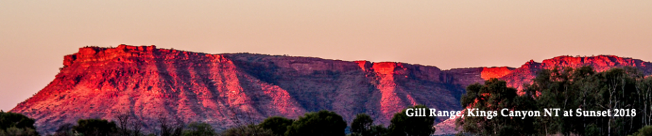
Travelled through fairly barren terrain, toward Mt Augustus, where we plan to stay at least two nights.

Gibber plains, powdery red sand, floodways, dips, stunted trees – typical Australian outback country, until a row of green indicates a creek or river crossing.

The Lyons River joins the Gascoyne River and we crossed it into Kennedy Ranges and crossed it again, several times, on this trip.

MOUNT AUGUSTUS

The mountain, or asymmetrical anticline – rock layers that have been folded into an arch-like structure – which is 1105 metres above sea level and is twice the size of Uluru (Ayers Rock). It is a granite formation, about eight kilometers long, covering an area of 4,795 hectares and is estimated to be 1750 million years old. The photo to the left was of our first sighting. The MM our awestruck by the size of it and they are hanging on for their lives!

We are on an unpowered site, but have mains water to our van, septic toilets and can buy basic supplies here. There is much more space in the camping section and we can have a fire.

Day 2

Drove to Cattle Pool, walked for a Km or so, along a permanent waterhole on the Lyons River, which was used by the station owners, over the past 150 years as their water source, for both human consumption and cattle.

We lunched by this waterhole and sat for a long while, feeling like we could have been the only people in the world.

Meanwhile, in the quiet, waterbirds and honeyeaters flew in around us, butterflies, and insects. Everything seems to come to you if you are patient enough.

We are enjoying it here, except for the lack of communication and contact with family and friends.

MM had loads of fun on the massive red river gums and were daring each other to go just that little bit further. “Trust me” said the yellow one, as he encouraged the others to follow him skidding down the tree, to dive in.

The flowers have been amazing and we’ve bought two books, so we now know the names.

Day 3

Decided to stay another day here – such an interesting place and last night we went over to the bar and dining room, where Candy the aboriginal owner sat at our table and told us all about the Wajarri people, who once lived here. Their name for the rock is Burringurrah.

Today we walked into Oooramboo and Mundee to see aboriginal engravings. There was an eerie feeling for me at Ooramboo – can’t explain it.

Walked ingto Kotka Gorge, which incorporates the Gum Grove Trail. Quite hot walking over rock, even though there is extensive cloud cover. Didn’t go the whole way, as the walking became too difficult – climbing over large boulders etc. Lots of lovely flowers and bushes on the way, and incredible red gums, that we had to duck under, weave around and marvel at their presence.

At the end of our walk, we sat at a picnic table to eat our egg and lettuce sandwiches, thinking we’d have a leisurely break, until a few spots of rain made us make a hasty retreat, back home, to take down the canvas roof. Resumed our relaxing lifestyle after 15 minutes of furious work, even though the rain was only at the rock and not back at camp.

MM had a ball playing on the Karavan, trying to get into our bed. They were missing Rhys and Heath badly yesterday, so last night we let them sit around the fire and sang songs. Yellow MM has a shocking voice, but we wouldn’t dare tell him!

We are leaving tomorrow for Tom Price where we will be able to publish all this and talk to our kids again.

Posted in 2008 | 1 Comment

Kalbarri – Gascoyne Junction – Kennedy Ranges

Left Kalbarri for our mid-west adventure to Kennedy Ranges National Park. Tonight’s destination is Gascoyne Junction, almost 500kms.

Vegetation north of Kalbarri is very lush, with taller trees and a carpet of pin, vibrant and white flowers in patches, grasses with rust-coloured tops waving in the wind, like a wave. Red sand sets the scene off, with wattles coming into bloom.

Paid $2.05 for diesel at Billabong Roadhouse, where I picked up a cappuccino.

There is scrub past Billabong, with clusters of purple flowers.

We tried taking photos of the flowers, but please forgive them being out of focus. Temperature is 20 degrees at 11:15am.

Crisped up some rolls for our roadside lunch stop, filled with ham and tomato. 22 degrees now, but feels much hotter.

Vegetation has changed since the stop – almost bare plain now – almost what I expected the Nullabour to be like, except for all the patches of purple and yellow, here and there. Flat as far as the eye can see.

MM stretched their legs, and ate well, quiet in the car after painting the town red and surfing, visiting gorges in Kalbarri. They were keen to take a hike down the steep side, but I managed to get a hand to them just in time. What will be in store for us, after they’ve revived?

Left the main highway to the north to take a “short cut” to Gascoyne Junction. Paid $2.09 for fuel at Wooramel. The scenery is spectacular on each side of the road now, with green, larger trees everywhere. Floodway signs and pools of water either side of the road, traveling over small sand dunes, along a wonderful red sand road.

Stopped at Gascoyne Junction Hotel for the night, $10 pp, with power. We only had 66 kms to go to get to Kennedy Rg, but such an interesting little pub, needed a visit. The only downside here was that we topped up with diesel, advertised at the bowser at $1.90, and after the owner pumped 38 litres out of a drum, into our car, he told us that it was $2.35 pl!

Day 2

Crossed the Gascoyne River – MM keen to have a swim, but we promised them a great time at Kennedy Ranges. Defiant as they are, they insisted on climbing up to the top of the windmill – little rascals!

11am and set up at this amazing range. Travelling all the way toward the range, our expectations grew higher and higher, until we set up in Temple Gorge, surrounded by sandstone and shale cliffs, like a three-sided amphitheatre. We have watched the goats run along, what seem like, the narrowest of ledges.

Our poor little MM were completely exhausted on arrival and we left them sleeping peacefully in the car.

Walked into Temple Gorge. There were two grades of tracks, one Grade 3, the other Grade 4, and we walked through this spectacular gorge until the boulders were too big for me to get over, which was 7/8ths of the way. Russ got to the end, where there was a lovely permanent pool.

Returned back to camp for a half an hour break then drove to Honeycomb Gorge. After a short, but hot walk, we were again treated to another amazing gorge, varying all the time from sandstone, to what appeared to be explosions of ironstone.

Came home to shade, a late lunch while, staring at the gorge from every angle, leading to a great discussion about how you would go about painting the gorge in watercolour. I recalled so much of Jean Cowan’s lessons, but putting it into practice is another matter!

Posted in 2008 | Leave a comment

Last Night Spreeeeee!

“Show me the way to go home, I’m tired and a wanna go to bed, I had a little drink about an hour ago, and it’s gone right to my head. Wherever I may roam, over land and sea and foam, you’ll always hear me singing this song, show me the way to go home”!

hav’n a bit of truble get’n to bed – had a gooood time tho! Oh, Oh, here comes Marg! See ya later!

Sorry about that, lost control of the MM least expected to go out on the town. He looks happy enough though, I’ll just make sure he gets a serve of bacon and eggs in the morning!

Can’t leave this place without trying to portray the view from our caravan park. The photos don’t show the dangerous entrance from the Indian Ocean to the Murchison River, but here we go again, at trying to give you some good photos.

Hic! from OM

Posted in 2008 | 2 Comments

Up and Away Again

This may be the last blog before we set off, heading North. The MM are anxious to get going, although they will miss the spectacular views of the coast, south of Kalbarri. Trust them to get the best vantage position!

We are going to Gasgoin Junction, then to Kennedy Ranges, Mt Augustus and beyond. Loads of kms to travel, but from what we hear from other travellers, it sounds as if it will be great when we get there. We will then head back to the coast, which will be long after the school holidays have finished.

The weather has changed here, rained last night and today the wind is quite cool, but lovely when the sun is not behind a cloud.

Speak to you all in a week or so, unless 3G enables us to keep in touch!

Posted in 2008 | Leave a comment

Blog for the Rhys and Heath (others too of course)

We had a lot of work to today. We are packing up on Sunday, so there was washing to do, a drain to be cleared and stocking up on meat and vegies.

The MM protested about all the boring stuff and insisted on going surfing. They checked out our site number, before setting off, so they knew where to return.

They had a great time! Mr Yellow took control of them all and Mr Orange looked after Mr Green, who always is little scared of new things. They all get along very well and are sharing all their new adventures.

They are back now and are climbing up onto the table to see how great they look with their surfboards.

They returned earlier than expected, because rain is forecast. They are loving being out in the sun and cloudy days are just not their thing!

Looks like I have to think of something substantial for them to eat for their tea – they tell me they are ravenous.

Posted in 2008 | 1 Comment

Kalbarri – This time South

The Kalbarri National Park surrounds the entire town of Kalbarri, and today we took our lunch and headed south along the coast road.

The first point of interest was Red Bluff, a popular beach with the locals and tourists. The Zuytdorp Cliffs, to the north, extend more than 200kms to Shark Bay. Eagle Gorge was the next attraction for us, where the visit could extend to the beach if required.

The MM fancied the view and it was difficult to hold them back from the incredibly high drop!

A bit further on were Shellhouse and Grandstand, then Castle Cove, Island Rock (1st pic), and Natural Bridge, (2nd photo). In all of these attractions, you can see the force of the Indian Ocean on the limestone cliffs, reminding us a lot of the Great Ocean Road in Victoria.

Magnificent ocean views all the way and at each stop and interesting cliffs.

We continually looked out to sea to spot some whales, and were luck enough to see, a few times, the black hump of one, closer in. Some spectacular splashes further out, but we’d be lying if we said we could see the whale! Only the splash it made. Still exciting though.

We have bought a book on wildflowers so now I should be able to name them for you. The purple one, is Rough Honeymyrtle, Malaleuca Parviceps, but, guess what, the other one isn’t in the book, but we think it is a Dryandra!

I’m typing this outside today – it’s fairly hot – 26 degrees and little breeze. We found a lovely shady spot, beside an inlet, to have lunch. There was a monument to the first Dutch explorers, who, in 1606, were shipwrecked 90 miles south west of here. The survivors stayed on an island between here and Indonesia, and many were murdered by mutineers. The Captain of Batavia, the shipwrecked vessel, returned to the island, round up the mutineers and hanging them. The story ends with two of the Mutineers being extended mercy, by putting them ashore on what we now know as ‘Australia”. No-one knows of their fate to this day.

Posted in 2008 | 1 Comment